
YELLOWMAPS
YellowMaps Busby MT topo map, 1:24000 Scale, 7.5 X 7.5 Minute, Historical, 1958, Updated 1960, 26.9 x 22 in - Polypropylene
AED 613.66
AED 1,022.77
-
 Order within 46 minutes to get between June 17 - June 23
 -
 Tracked Shipping on All Orders
-
 14-Day Returns
- Secure Payments
-
 24/7 Customer Support
Description
- Printed on Polypropylene (plastic)
- USGS topographic map of Busby, MT, at 1:24000 scale. Heavier material. Waterproof. Tear-resistant. Foldable. Perfect for the outdoors.
- Cities, towns, villages: Busby
- Islands: Consult topo map preview for visible islands.
- Parks and forests: Indian Chief Two Moons Historical Monument
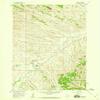
USGS topographic map of Busby, Montana, dated 1958, updated 1960.
Includes geographic coordinates (latitude and longitude), lines of elevation, bodies of water, roads, and more. This topo quad is suitable for recreational, outdoor uses, office applications, or wall map framing.
Printed on-demand by YellowMaps on the print material of your choice.
Shipping rolled from Minneapolis, MN, United States.
Product Number: USGS-5391958
Map Size: 26.9 inches high x 22 inches wide
Map Scale: 1:24000
Map Type: POD USGS Topographic Map
Map Series: HTMC
Map Version: Historical
Cell ID: 6418
Scan ID: 262755
Imprint Year: 1960
Woodland Tint: Yes
Aerial Photo Year: 1956
Field Check Year: 1958
Datum: NAD27
Map Projection: Polyconic
Map published by United States Geological Survey
Map Language: English
Scanner Resolution: 600 dpi
Map Cell Name: Busby
Grid size: 7.5 X 7.5 Minute
Date on map: 1958
Geographical region: Montana, United States
Northern map edge Latitude: 45.625
Southern map edge Latitude: 45.5
Western map edge Longitude: -107
Eastern map edge Longitude: -106.875
Surrounding map sheets (copy & paste the Product No. in the search bar):
North: USGS-5392278
East: USGS-5397378,USGS-5397380
South: USGS-5391462,USGS-5401490,USGS-5391460
West: USGS-5401548,USGS-5395256
Shipping and Returns
- We offer tracked shipping on all orders. Tracking information will be shared as soon as the order is dispatched.
- Please check the delivery estimate before adding a product to the cart. This is displayed for every product on the website.
- Available shipping methods and charges will be displayed at the time of checkout, depending on your exact location.
- All customers are entitled to a return window of 14 days, starting from the date of delivery of the product(s).
- Customers are advised to read our return policy for details of the return process, eligibility, refunds as well as cancellations or exchanges.
- In case of any issues or concerns about Shipping or Returns, please contact us and we will be happy to help.
YellowMaps.
YellowMaps Busby MT topo map, 1:24000 Scale, 7.5 X 7.5 Mi...
AED 613.66
AED 1,022.77