
YELLOWMAPS
YellowMaps Cameron AZ topo map, 1:100000 Scale, 30 X 60 Minute, Historical, 1982, Updated 1983, 23.9 x 42.3 in - Tyvek
AED 786.40
AED 1,310.67
-
 Order within 5 hours and 22 minutes to get between June 17 - June 23
 -
 Tracked Shipping on All Orders
-
 14-Day Returns
- Secure Payments
-
 24/7 Customer Support
Description
- Printed on Tyvek® (synthetic)
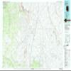
- USGS topographic map of Cameron, AZ, at 1:100000 scale. Lighter material. Waterproof. Tear-resistant. Foldable. Very durable. Perfect for backpacking and the outdoors.
- Cities, towns, villages: Gray Mountain,Black Falls Crossing,Cameron,Tiis Holoni
- Mountains: Middle Mesa,North Mesa,Sinking Ship,Lii Haaditiih Hill,Doney Mountain,Little Gray Hill,The Landmark,Gray Mountain,Missouri Bill Hill,Tohnali Mesa,Antelope Hill,S P Mountain,Sand Springs Mesa
- Valleys: Pothole Canyon,Lockwood Canyon,Kanaa Valley,Tappan Spring Canyon,Moenkopi Wash,Burro Canyon,Hulls Canyon,Lee Canyon,Dead Indian Canyon,Cedar Canyon,Box Canyon,To Nahakaad Wash,Landmark Wash
Shipping and Returns
- We offer tracked shipping on all orders. Tracking information will be shared as soon as the order is dispatched.
- Please check the delivery estimate before adding a product to the cart. This is displayed for every product on the website.
- Available shipping methods and charges will be displayed at the time of checkout, depending on your exact location.
- All customers are entitled to a return window of 14 days, starting from the date of delivery of the product(s).
- Customers are advised to read our return policy for details of the return process, eligibility, refunds as well as cancellations or exchanges.
- In case of any issues or concerns about Shipping or Returns, please contact us and we will be happy to help.
YellowMaps.
YellowMaps Cameron AZ topo map, 1:100000 Scale, 30 X 60 M...
AED 786.40
AED 1,310.67