
YELLOWMAPS
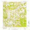
YellowMaps Devils Tower WY topo map, 1:62500 Scale, 15 X 15 Minute, Historical, 1955, Updated 1957, 20.9 x 16.1 in - Tyvek
AED 661.66
AED 1,102.77
-
 Order within 48 minutes to get between June 17 - June 23
 -
 Tracked Shipping on All Orders
-
 14-Day Returns
- Secure Payments
-
 24/7 Customer Support
Description
- Printed on Tyvek (synthetic)
- USGS topographic map of Devils Tower, WY, at 1:62500 scale. Lighter material. Waterproof. Tear-resistant. Foldable. Very durable. Perfect for backpacking and the outdoors.
- Cities, towns, villages: Carlile Junction,Hulett,Devils Tower
- Mountains: Storm Hill,Manly Hill,Sherrard Hill,Newton Hill,Devils Tower,Moore Hill,Cockscomb Hill
- Valleys: Schiller Canyon,Barlow Canyon,Moore Canyon,Campstool Draw,McQue Draw,Burnt Hollow,Myers Canyon,Barnard Canyon,Sawmill Gulch,Red Canyon,Nelson Canyon,Davis Canyon,Bush Canyon
Printed on Tyvek
Shipping and Returns
- We offer tracked shipping on all orders. Tracking information will be shared as soon as the order is dispatched.
- Please check the delivery estimate before adding a product to the cart. This is displayed for every product on the website.
- Available shipping methods and charges will be displayed at the time of checkout, depending on your exact location.
- All customers are entitled to a return window of 14 days, starting from the date of delivery of the product(s).
- Customers are advised to read our return policy for details of the return process, eligibility, refunds as well as cancellations or exchanges.
- In case of any issues or concerns about Shipping or Returns, please contact us and we will be happy to help.
YellowMaps.
YellowMaps Devils Tower WY topo map, 1:62500 Scale, 15 X ...
AED 661.66
AED 1,102.77